


Version 2.1.132 ©2025 Data accuracy not guaranteed


| Lots Only | |
| Lots + Roads | |
| Detailed View | |
| 50% Aerial Aerial photo May 2021 |
|
| Aerial + Roads Aerial photo May 2021 |
|
| Drone Imagery (2023-2024) Flight date is on each image |
|
| Spexi Imagery | |
|
|||||||
| Utility Company Right of Way |
|
||||||
| Buildings (May 2021) |
|
||||||
| Existing Boreholes For more information, contact DARES (604-793-2902) |
|
||||||
| Latecomer Agreement Properties on unexpired Tempest Latecomer Agreements. Data is a snapshot from the end of the previous work day. |
|
||||||
| Active Projects Properties on ACTIVE or ON HOLD Tempest Land Dev or Planning folders. Data is a snapshot from the end of the previous work day. |
|
||||||
| DP3 Projects Properties on Tempest folders with a riparian area review |
|
||||||
| City Owned E.g. parks, landfill, rental property, holding property, vacant land. For more information, contact Property Management (604-793-2907). |
|
||||||
| Building Inspection Areas | |||||||
| Address Grid |
|
||||||
| Firehalls |
|
| Schools |
|
| 10 Minute Response Time (Firehall 1) |
|
| Bylaw Enforcement Officer |
| Zoning | legend | |||
| OLD Zoning Bylaw 2001 | ||||
| C8 Zone Buffer |
|
|||
| Official Community Plan | legend | |||
| Eastern Hillsides Dev Cells | legend | |||
| Agricultural Land Reserve |
|
|||
| Development Permit Area | legend | |||
| Downtown Tax Exemption | details | |||
| Firearm Discharge Prohibited |
|
|||
| Marble Hill | legend | |||
| Urban Growth Boundary |
|
|||
| Neighbourhoods |
|
|||
| Curbside Collection Area | details | |||
| Business Improvement Area | ||||
| Capital Projects | legend | |||
| Population Density Source: Statistics Canada 2021, 2016 and 2011 Census (undercount adjusted). This information is published as general reference only and is subject to correction or change. |
legend | |||
| Small-Scale Extension An extension granted by the province to delay small-scale housing to 2030. For more information, contact Planning (604.793.2906). |
|
|||
| Small-Scale Housing This layer is only updated occasionally. For up-to-date information, contact Planning (604.793.2906). |
legend | |||
|
||||
| Heritage | legend | |||
| Heritage Interest |
|
|||
| Section Map Grid for map book pdf Click number to view 1983 Zoning Bylaw map book pdf |
|
|||
|
||||
| Floodplain | legend | ||||||
| Watercourses |
|
||||||
| Dykes |
|
||||||
| Contours 2021 m |
|
||||||
| Ground Elevations 2021 m |
|
||||||
|
|||||||
| Wildlife Issues Areas |
|
||||||
| Geohazard | legend | ||||||
| Watercourse Class | legend | ||||||
| Soil Capability | legend | ||||||
| Catchment |
|
||||||
| Subwatershed |
|
||||||
| Watershed |
|
||||||
| Knotweed | legend | ||||||
| Bank Protection |
|
||||||
| Fire Hydrants |


|
|||
| Water Water utilities marked preliminary are derived from unofficial technical drawings and are approximations only |
|
|||
|
||||
| Storm Storm utilities marked preliminary are derived from unofficial technical drawings and are approximations only |
|
|||
|
||||
| Sanitary Sewer Sanitary utilities marked preliminary are derived from unofficial technical drawings and are approximations only |
|
|||
|
||||
| Water Pressure Zones | |
| Utility Pipe Labels | |
| Utility Manhole Labels | |
| Storm Catchbasin Labels | |
| Sanitary ForceMain Flow Direction | |
| Abandoned Pipe |
|
| Standpipes/Taps |


|
| SCADA | legend |
| Storm Tanks |


|
| Water Meters Collected in the field by Operations staff, not reviewed |

|
| Inspection Chamber Collected in the field by Operations staff, not reviewed |
|
| Double Check Valve Collected in the field by Operations staff, not reviewed |

|
| Fibre Optic |
|

| Search Results |

|

| Property Report |
|

|
|
PDF
loading...
|
|
| Assessment | Owners | Taxes | Utilities |
| Print/Save Map |
|
| Map only: | ||
| Title: | ||
| Size: |
Note: may take 2-3 minutes
|
|
| Orientation: | ||
| Scale | ||
| Create as: | ||
| Tools |
|
 Streetview
|
Share
|
 Area
|
 Distance
|
 Location
|
Delete all
 Display angle on labels. Angle is measured clockwise from the north. 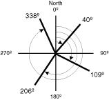 Angle |
 Line
|
 Area
|
 Text
|
Edit
|
Delete all
Save
Open
Save drawings to file
Once you've added drawings to the map, you can click the Save button and save them to an external XML file.
This allows you to save the current state of your drawings, share with others, and open the drawings again later.Open drawings from file
Click the Open button and select a previously saved XML drawing file. The drawings will be added to the map.
|
| Legend |
|
|
PDF
|
|
| Help |
|
| What's New |
|


